Introduction to Projections and Coordinate Systems#
Mapping the Earth on a Flat Surface — A Core Concept in Cartography
Representing the curved surface of the Earth on a flat map is one of the most practical and fundamental challenges in cartography.
In this section, we’ll explore why coordinate systems and map projections are necessary, why there are so many of them, and how understanding these concepts can help you avoid common mistakes when creating or analyzing maps.
You’ll learn how projections affect shape, distance, area, and direction — and how to choose the right one for your spatial analysis.
Short theory#
We need to represent the surface of a 3D sphere — the Earth — on a flat 2D surface. Unfortunately, this can’t be done without some distortion.
To see exactly why that is, check out this great video: 👉 Why all world maps are wrong
That’s exactly why we need… map projections — systems designed to translate the Earth’s curved surface onto a flat map, each with different ways of managing distortion.
Map Projections#
A map projection is a method of transforming the Earth’s complex, curved surface into a flat two-dimensional representation.
When projecting geographic data onto a map, distortions inevitably occur — in angles, areas, distances, or sometimes all of them at once. Depending on which property is preserved, a projection may be:
Conformal (preserves angles),
Equidistant (preserves distances),
Equal-area (preserves area), or compromise/general-purpose projections that distort all properties to some extent.
Some projections are designed to represent the entire world, but most are optimized for specific regions, minimizing distortion over smaller areas.
Projections are also grouped based on the type of projection surface used to “unwrap” the globe — such as a cylinder, cone, or plane.
A great interactive tool to explore more than 100 different map projections is the Map Projection Explorer. It shows what kind of distortions each projection introduces, what projection surface it’s based on, and what the world looks like when drawn with each method. 🗺
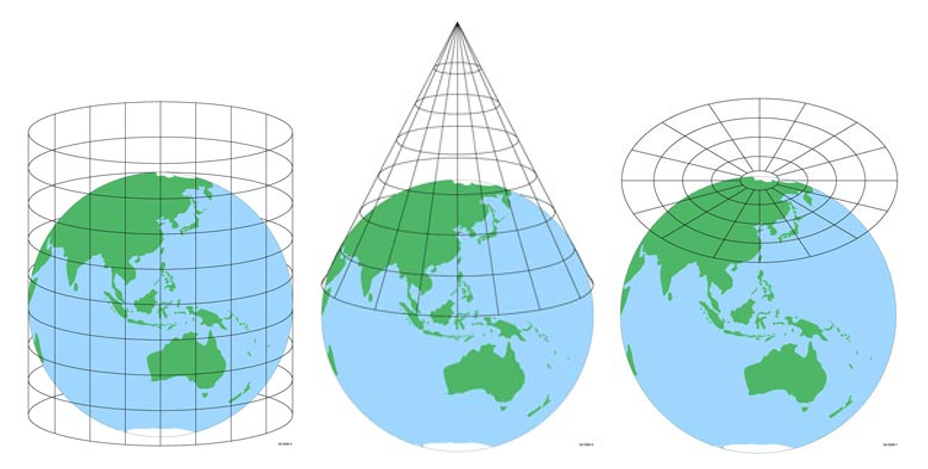 Image source: ICSM.gov.au
Universal Transverse Mercator (UTM) Projection#
The Universal Transverse Mercator (UTM) projection is one of the most widely used and practical systems for mapping the Earth.
It works by dividing the Earth’s surface into 60 longitudinal zones, each 6 degrees wide. These zones are defined separately for the northern and southern hemispheres, resulting in a total of 120 projection zones globally.
Each UTM zone has its own central meridian, which serves as the reference line for the projection in that area.
By dividing the globe into many narrow zones, the UTM system minimizes distortion within each individual zone, making it ideal for local and regional mapping.
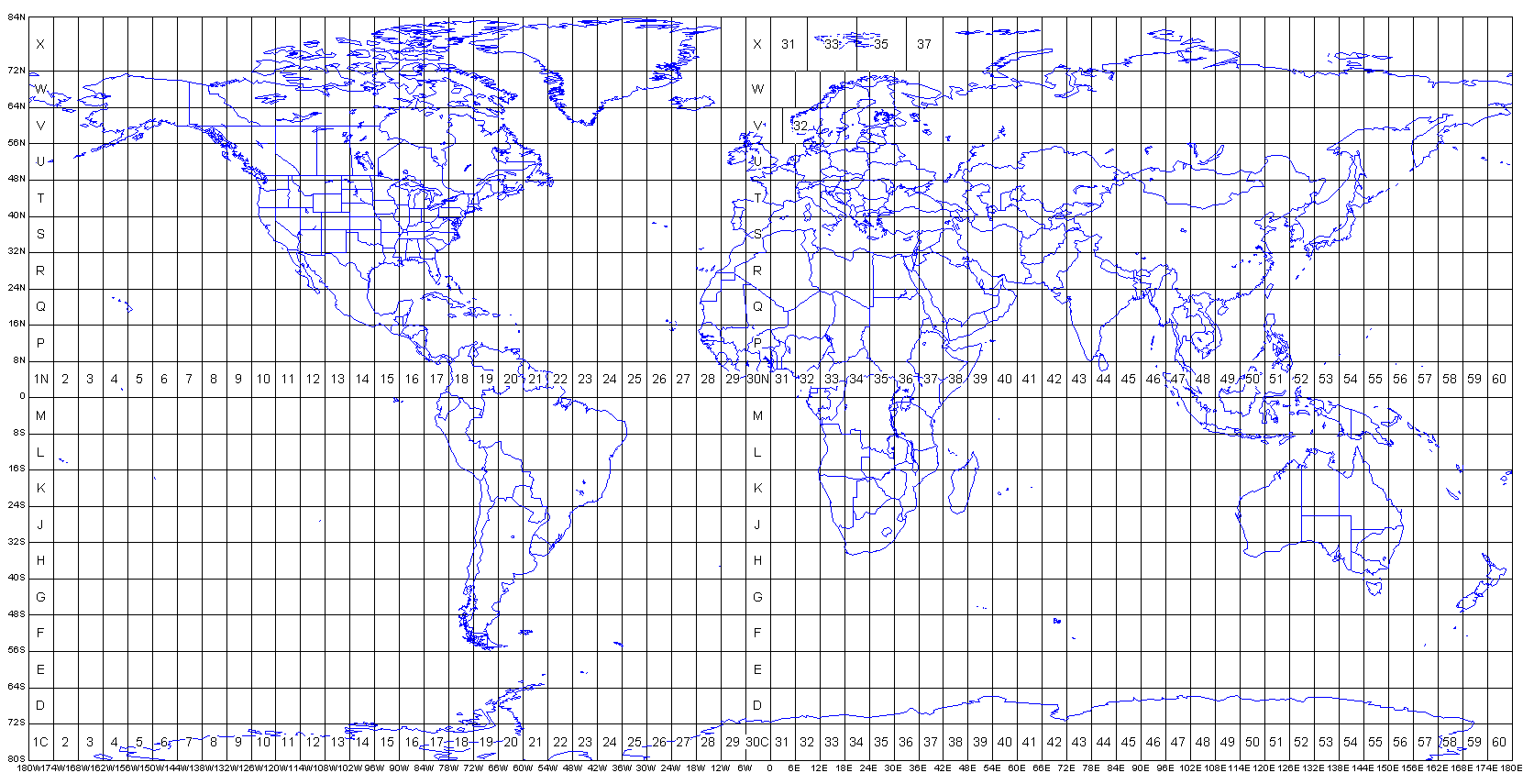 Image source: Dmap.co.uk
Coordinate Systems#
A coordinate system is a way to specify the location of points on the Earth’s surface.
🌍 Geographic Coordinate Systems (GCS)#
Geographic coordinate systems are familiar from school geography lessons. A point’s location is defined by latitude and longitude in degrees. With just these coordinates, you can easily find a place on a map — no extra context needed.
For example: 59°57′ N, 30°19′ E — the coordinates of Saint Petersburg ❤️
One of the most widely used geographic coordinate systems is WGS 84. It’s the default system for most open datasets, GPS devices, and mobile tracking apps.
📐 Projected Coordinate Systems (PCS)#
Projected coordinate systems define locations on a flat map. Each point is described by two values — X and Y — measured from a central origin point.
However, without knowing the specific projection used, raw X and Y values won’t tell you where something is in the real world, because the origin point and scale depend on the projection.
Units in projected systems are linear — such as meters, kilometers, or feet — making them ideal for measuring distances and areas accurately.
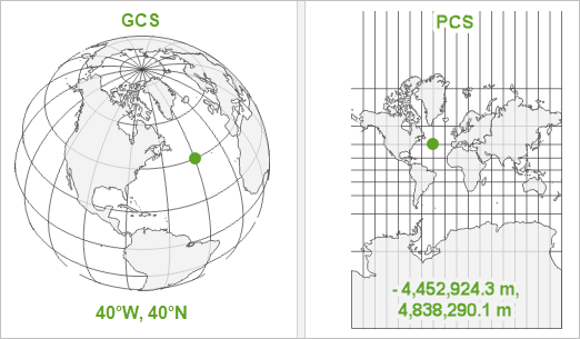 Image source: esri.com
🔢 EPSG Codes#
EPSG (European Petroleum Survey Group) codes are numerical identifiers used to uniquely define coordinate reference systems, map projections, and geodetic datums. Originally developed by the European Petroleum Survey Group for use in the oil and gas industry, these codes are now widely adopted in geographic information systems (GIS).
For example, the most common geographic coordinate system — WGS 84 — is identified by EPSG:4326.
📐 EPSG Codes for UTM Zones#
The EPSG code structure for UTM coordinate systems follows a predictable pattern:
EPSG:326xx — for zones in the Northern Hemisphere, where
xxis the UTM zone numberEPSG:327xx — for zones in the Southern Hemisphere, where
xxis the UTM zone number
These codes are essential for setting or converting coordinate systems in GIS software or libraries like GeoPandas, PROJ, or QGIS.
Getting Information about CRS#
Export City boundary from OSM and learn about its CRS
import osmnx as ox

admin_border = ox.geocode_to_gdf('Vienna, Austria')
admin_border.explore(tiles='cartodbpositron')
admin_border.crs
<Geographic 2D CRS: EPSG:4326>
Name: WGS 84
Axis Info [ellipsoidal]:
- Lat[north]: Geodetic latitude (degree)
- Lon[east]: Geodetic longitude (degree)
Area of Use:
- name: World.
- bounds: (-180.0, -90.0, 180.0, 90.0)
Datum: World Geodetic System 1984 ensemble
- Ellipsoid: WGS 84
- Prime Meridian: Greenwich
Let’s break down what this means:
This is a geographic coordinate system using two-dimensional coordinates (latitude and longitude), and its identifier is EPSG:4326.
CRS Name: WGS 84
Axis Info: Uses ellipsoidal coordinates — latitude (Lat) and longitude (Lon). Units are degrees.
Area of Use: The entire world
Ellipsoid: WGS 84 — the mathematical model of the Earth’s shape
Prime Meridian: Greenwich — the zero-longitude reference
Did you know that the Greenwich Meridian was officially established as the prime meridian only in 1884? This decision was made at the International Meridian Conference in Washington, D.C.
Summary#
In this section, we explored the fundamentals of map projections and coordinate systems in cartography.
We learned how to:
Why projections are necessary and how they introduce distortions
Distinguish between geographic (latitude/longitude) and projected (X/Y) coordinate systems
Use EPSG codes to identify and apply the correct CRS in GIS tools and libraries